How to get  
Select a route from the map {{directionsToLabel}}
{{currentWaypoint.label}}

Q-Trail

Quarna (VB), Italy
Trail Running
Difficulties
Technique
Experience
Landscape
Length (Km) 21
Time 3
Average speed (km/h) 7
Starting altitude (m) 810
Arrival altitude (m) 810
Hightest point (m) 1330
Lowest point (m) 740
Altitude difference (m) 870
Period All the year
Waytypes Alpine hiking trail: 4,47 km
Hiking trail: 3,09 km
Path: 6,99 km
Street: 1,61 km
Road: 1,09 km
Unknown: 4,01 km
Surfaces Alpine: 4,42 km
Natural: 4,89 km
Unpaved: 4,71 km
Paved: 2,27 km
Asphalt: 483 m
Unknown: 4,49 km

Description

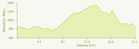
The Q-Trail is an annual competition that starts at Alpe Campello (Quarna Sopra) and runs on roads and paths that are not particularly technical.

The Q-Trail includes the 20 km loop trail, which is the subject of this track and reaches a maximum altitude of 1300 metres above sea level, and the 9.5 km trail, which is almost entirely single track.

For more information: www.quarnaoutdoor.com

Surroundings

{{count}}/{{totalCount}} Upload More