How to get  
Select a route from the map {{directionsToLabel}}
{{currentWaypoint.label}}

Antonelliano Route

Romagnano Sesia (NO), Italy
Road Cycling
Difficulties
Technique
Experience
Landscape
Length (Km) 41
Time 3
Average speed (km/h) 13
Starting altitude (m) 300
Arrival altitude (m) 300
Hightest point (m) 330
Lowest point (m) 330
Altitude difference (m) 310
Period All the year
Waytypes Singletrack: 246 m
Path: 18,2 km
Cycleway: 402 m
Street: 6,06 km
Road: 15,8 km
State Road: 411 m
Unknown: 192 m
Surfaces Unpaved: 16,4 km
Cobblestones: < 100 m
Paved: 7,93 km
Asphalt: 16,3 km
Unknown: 713 m

Description

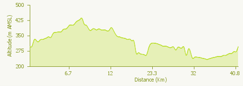
The proposed tourist cycling route is a ring ride with a total length of 41 km which, winding through the Novara hills, will lead you to the discovery of some fascinating places, rich in history.

Departure and arrival are in Romagnano Sesia and the itinerary, ideal for traveling from spring to autumn, goes through Monte Fenera Park, Piano Rosa and Baraggia, touching bits of woods and vineyards as well as the characteristic towns of Boca, Maggiora, Fontaneto d 'Agogna and Ghemme.

Surroundings

{{count}}/{{totalCount}} Upload More