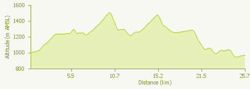
Lago Maggiore ZipLine Trail is a route that goes through a territory rich in charming scenic landscapes and which offers breathtaking views overlooking the lake and the surrounding valleys. It takes place within the historical and scenic context of the upper Intrasca Valley, with a stretch inside Val Grande park, in Upper Piedmont.
Lago Maggiore ZipLine Trail is an annual scheduled competition that offers multiple routes; in addition to the long Trail, object of the GPX attached to this itinerary, we point out:
The short trail of 11 Km. With 450 meters D+
Non-competitive walking and Nordic Walking
Departure and arrival are scheduled to take place at Alpe Segletta in Aurano (VB).
For more information on the race, consult the official website of the event.