How to get  
Select a route from the map {{directionsToLabel}}
{{currentWaypoint.label}}

Macugnaga: Nordic Walking between Lake Delle Fate (of the Fairies) and the Città Morta (Dead City)

Macugnaga (VB), Italy
Walk & Hike
Difficulties
Technique
Experience
Landscape
Length (Km) 6
Time 2
Average speed (km/h) 3
Starting altitude (m) 1360
Arrival altitude (m) 1390
Hightest point (m) 1390
Lowest point (m) 1220
Altitude difference (m) 190 uphill, 160 downhill
Period Estate / Autunno
Waytypes Alpine hiking trail: 457 m
Hiking trail: 916 m
Path: 4,12 km
Road: 343 m
Surfaces Alpine: 457 m
Natural: 305 m
Unpaved: 4,69 km
Asphalt: 390 m

Description

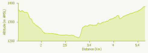
The itinerary, overall 12 km long, starts from Macugnaga, Pecetto hamlet and continues towards Staffa, Isella, Motta, Lake Delle Fate, Città Morta, Motta, Isella, Opaco, Pecetto.

The route extends along a dirt road and some asphalted surfaces and there is a difference in height of 250 meters (maximum altitude in Pecetto 1367 meters - minimum altitude in Isella 1247 meters)

The recommended period for the itinerary is from May to October.

Data source: © Municipality of Domodossola - www.visitossola.it 

Surroundings

{{count}}/{{totalCount}} Upload More