The Lupi del Cornaggia are a group of enthusiasts who trace, clean and keep up some trails devoted to open descent riding via MTB located in Alto Vergante.
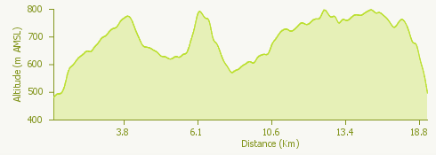
The network of trails available in this area is extremely vast, and the one indicated in this itinerary, and to which the downloadable GPX refers, is the "Cornaggia T1" classified with Difficulty rating of Black Diamond, that is, as a route with some very technical and exposed stretches, large obstacles and jumps.
It is therefore reserved for cyclists with excellent technical skills.
All of the Lupi del Cornaggia trails are available at Trail Folks.
© Lupi di Cornaggia