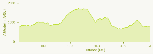
The proposed itinerary starts from Piana di Vigezzo, taking the cycle path to Druogno.
Once in the village, the route climbs to Albogno and follows the mule track that leads to Crana; it then continues on asphalt and dirt road through Toceno and Craveggia, before climbing towards Colma.
At Colma di Craveggia one takes the climb towards Alpe La Colla and in La Vasca climbs up towards Alpe Blitz; continuing, between dirt and cobblestones, the path arrives at the Sanctuary of Re.
From here the route rejoins the cycle path in the direction of Malesco and continues uphill to Alpe Laurenzo; then one rejoins the Druogno-Re cycle path to return to the starting point.
© Piana di Vigezzo