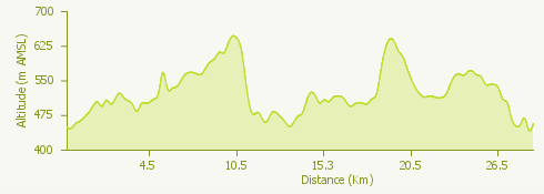
The proposed itinerary develops in a ring around the slopes of Campo dei Fiori.
The starting point is the car park near the cemetery of Sant'Ambrogio. An uphill stretch of road is followed in the direction of Sacro Monte, turning into Via Adige until reaching the historic centre of Velate. From here the itinerary follows the signs for trail no. 10/310.
The first part of the route is along dirt tracks and easy paths until the junction for Cerro, where there is a challenging bumpy descent leading to the Cerro-Orino dirt track.
After passing the picnic area one reaches Orino, continuing downhill on asphalt until returning to the woods and reaching the Rocca di Orino.
Path 10b/310b continues in the direction of Brinzio; having passed the village, the route continues uphill to an easy mule track that leads to the Campo dei Fiori Nature Park.
A gentle climb leads to the Motta Rossa pass, where a path leads to the hamlet of Rasa. From here, one continues on a dirt road to Molinetto and then near Villa Toeplitz to the starting point.