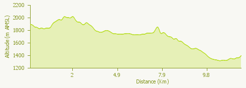
The starting point of this itinerary is Alpe Ciamporino, which can be reached from San Domenico via the ski lifts.We take the F50 route to Balma, entering Alpe Veglia. From Alpe La Balma we follow the path that leads to Cornù, where visitors can refresh themselves thanks to the presence of various accommodation facilities.
Through the F10 route, passing by the Fornace and the waterfall of Rio Frua, we continue on a stretch of mule track downhill to the bridge over the Cairasca stream and from here to the Casa del Parco-Porteia.
We take the path as far as the Groppallo Chapel and continue downhill as far as the path to Ponte Campo. Then we take the asphalted road to the centre of San Domenico.