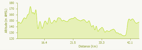
The starting point of this itinerary is the Terdoppio Sports Centre of Novara from which we continue in the direction of Pernate until we reach Galliate where, turning left onto Viale Cavour and then Via Varzi, we arrive at the level crossing.
We follow the railway and, after a second level crossing, we continue in the direction of Cascina Soliva and continue on a dirt road until we reach the cycle path of the Ticino Park (path E1).
Continuing on the cycle path we arrive at Villa Picchetta di Cameri, headquarters of the Ticino and Lake Maggiore Park Authority, and then to "La Quercia", which is equipped with amenities.
Continuing on path E1 we reach the Mulino Vecchio in Bellinzago and then Cascina Sant'Antonio. Turning right we go along the SR 527 and take the junction for the Alzaia del Canale Naviglio Grande towpath, at the Enel power station in Tornavento.
We follow the path to the Centrale Enel in Turbigo, after which we reach the stone bridge that crosses the canal.
On the right, we follow the road that leads us to the bridge over the Ticino of Galliate, cross it and turn left. We climb a steep stretch and arrive in Galliate. From here we retrace the outward stretch in the opposite direction and return to the starting point.