How to get  
Select a route from the map {{directionsToLabel}}
{{currentWaypoint.label}}

Anello azzurro of Lago d’Orta

Omegna (VB), Italy
Trekking Bike
Difficulties
Technique
Experience
Landscape
Length (Km) 40
Time 3 hours
Average speed (km/h) 13
Starting altitude (m) 300
Arrival altitude (m) 300
Hightest point (m) 460
Lowest point (m) 290
Altitude difference (m) 780
Period All the year
Waytypes Singletrack: 8,55 km
Path: 3,87 km
Cycleway: 1,32 km
Street: 9,11 km
Road: 16,8 km
State Road: 190 m
Unknown: 656 m
Surfaces Natural: 8,76 km
Unpaved: 182 m
Dirt road: 1,18 km
Paved: 8,93 km
Asphalt: 20,3 km
Unknown: 1,11 km

Description

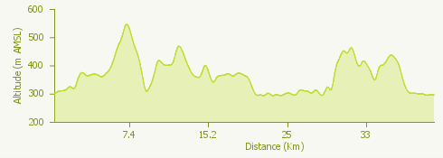
The itinerary starts from Omegna, on Lake Orta. From the train station, continue to Borca and take a path that, from the church, goes up to Crabbia.

Turning left (via ai Monti) continue on a path that takes us to Pratolungo and then to Pettenasco.

Continue in the direction of Carcegna and then Miasino, until Villa Nigra, where you turn right, towards Legro, following the signs for the Buccione Tower.

Proceed to Lagna, taking via dei Canneti and turning left to reach the main road.

Continue towards Ronco Inferiore and then towards Ronco Superiore reaching Oira, Brolo and Omegna.

Surroundings

{{count}}/{{totalCount}} Upload More