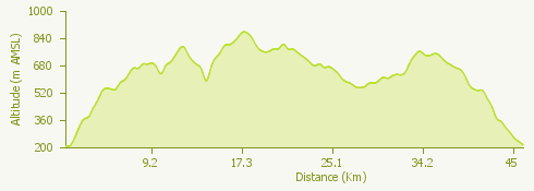
The Alto Vergante Tour covers a hilly area between the territories of Lake Maggiore and Lake Orta.
The panoramas visible along this itinerary, characterized by continuous ascents and descents, are of breathtaking beauty.
The departure is from Stresa, the "Pearl of Lake Maggiore", climbing up towards Vedasco, Vezzo and Gignese.
Once past the village, we continue on the asphalt road that leads to Armeno and after a short stretch, we turn left, on a road that leads us to the "Dorsale V" path, continuing until Colazza.
In the locality "La Rana" we follow a dirt path until Fosseno; after the village, we take the path that will lead us back to Gignese and, afterwards, to Vezzo.
From here we take the dirt path to the cemetery of Stresa.