Departure point:
Crevoladossola (VB), Italy
How to get there:
By train: Domodossola Station, Ferrovie dello Stato. Timetables: http://www.trenitalia.com/; www.ffs.ch
By bus: bus for Crevoladossola, line Domodossola – Cascata del Toce and North circular line. Timetables: www.vcoinbus.it
By car: A26 motorway to Gravellona Toce, then SS33 Sempione, after Domodossola take the exit for Crevoladossola
General Description:
Circular itinerary to discover a part of the route called “Via del Gries” in Crevoladossola and Montecrestese. In the Montecrestese territory were found interesting archaeological sites evidences attesting the presence of human settlements from pre-protohistoric ages (Iron ages, Fifth Century BC) up to the Roman Empire (First-Second Century AD) and in the Middle Ages. The area seems to have been particularly important regarding the sacredness aspect since the ancient times, represented by many structures with uncertain dates consisting in several megalithic complexes and a Gallo-Roman small temple.
The route:
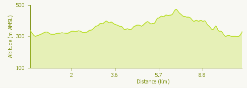
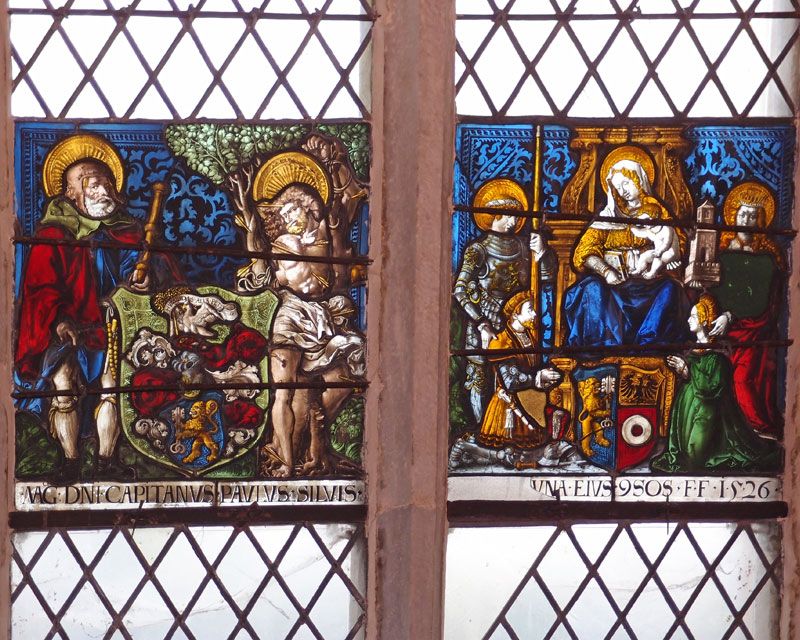
The itinerary starts at Crevoladossola’s Church, where you can admire the beautiful stained-glass windows made by a workshop in Bern and carried along the route “Via del Gries”. Following the signs for Via del Gries (trail G00) you will go down secondary roads up to the Enel Powerplant made by the Milan’s architect Portaluppi to continue up to Solaro where begins a nice paved mule track that runs alongside the Toce River, reaching the villages of Canova and Oira. From the small central square you’ll go up to the upper part of the village, at Villa of Oira, and then you take a nice mule track that goes down until it crosses the road for Val Formazza at Arzaloo. Cross the road to go down to the river and you will soon arrive at a nice stone arch bridge allowing you to reach Pontemaglio. The way back can be made along a different itinerary of the route Via del Gries (sentiero G00a) by taking the mule track going up to Chezzo and Lomese. From here you will start to go down the nice mule track of the Valle dei Cani, reaching a chapel and in the end you will go cross a road at a junction with a hairpin bend. Continue down to the Agriturismo AZ in the locality of Piaggino, walk along the Lake Tana and you will enter the road that will take you to the Church of Crevoladossola.
Useful information:
This itinerary can be recommended at all seasons except during summer, when there is usually an excessive and rapid growing of weeds that can confuse the track.
Where to eat:
Ristorante C’era una volta, Fraz. Oira 28865 Crevoladossola, VB, (IT) Tel. +39 0324 33294
Agriturismo A.Z., Loc. Piaggino 3, 28864 Montecrestese VB, (IT) Tel.+39 0324 35259 http://www.agriturismoaz.com