Departure point:
Crodo (VB), Italy
How to get there:
By train: Domodossola Station, Ferrovie dello Stato. Timetables: http://www.trenitalia.com/; www.ffs.ch
By bus: bus for Crodo, line Domodossola – Cascata del Toce. Timetables: www.vcoinbus.it
By car: A26 motorway to Gravellona Toce, then SS33 Sempione, after Domodossola take the exit for Valle Formazza and you will soon reach Crodo.
General Description:
Beautiful circular itinerary, feasible also during winter if there is little snow, to discover the surroundings of Crodo, the town of the mineral water of the same name and of the famous Crodino (nonalcoholic beverage).
The route:
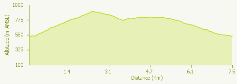
Departing from the centre of Crodo, follow the signs with the trail number G07 and enter on the nice trail that cuts through the turns of the Crodo – Mozzio road. The trail reaches first the village of Rondola, dominated by the signal tower, and then continues on to Mozzio intersecting the road. Turn left for a few meters and take the cobblestones track going up to the meadows until it suddenly ends at a house surrounding wall. Go left around the house to reach a small flat road leading to the hotel “Albergo Edelweiss” and then up to the centre of Viceno. Cross the village and go down remaining on the trail (G09) until you cross the road and then continue down until you reach the torrent Alfenza. Go up on the other side on a nice stretch of trail that leads to the locality of Vinun and thenyou will be on a flat trail up to a small chapel. From here – to visit Cravegna, the church dedicated to San Giulio and the old winepress – take the nice trail on the left. Then go back until you reach the small chapel and at this point you will start to go down up to Fariolo and Navasco (trail number G11). The mule track becomes very large and after a pair of curves you will arrive at the bridge on the torrent Alfenza. From here continue on the path, that will then be a road leading you to cross the road for Crodo – Mozzio and then you will soon be back in the centre of the village.
Useful information:
Latteria Antigoriana, Via Circonvallazione, Crodo VB, (IT) Tel. +39 0324 61081 www.latteriacrodo.it
Il Forno ossolano, Via Maglioggio 13, Crodo VB, (IT) Tel. +39 0324 61066 www.ilfornoossolano.it
Where to eat: Ristorante Edelweiss, Località Viceno n.7, Crodo VB, (IT) tel +39 0324 618791 www.albergoedelweiss.com