Departure point:
Stresa (VB), Italy
How to get there:
By train: Stresa and Baveno Stations, Ferrovie dello Stato. Timetables: http://www.trenitalia.com/; www.ffs.ch
By car: A26 motorway to Gravellona Toce, exit for Carpugnino (in direction of Gravellona Toce), or exit for Baveno (in direction of Genova). Then follow for Stresa and town centre.
General Description:
The first part of the itnierary is made using the cableway to the top of Mount Mottarone, and from there starts the trail going down to Baveno.
The route:
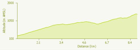
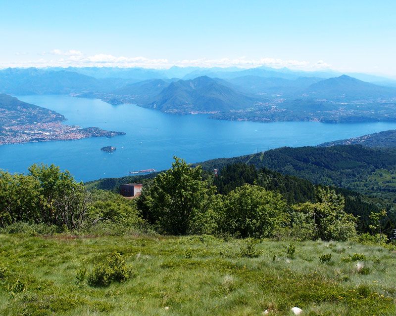
From Piazzale Lido of Carciano di Stresa is the departure of the cableway Stresa-Alpino-Mottarone that reaches the altitude of 1491 meters of Mount Mottarone in less than 20 minutes. From the top of the Mottarone go along the skilift and follow trail VM3 the refuge CAI Alpe Nuovo. From here you can quickly go up to the top of Mount Zughero, then down by the trail that was once used by the old granite quarry and that passing by the refuge Alpe Nuovo, leads to Alpe Vedabia. From Alpe Vedabia follow the trail that crosses a birch wood going up slightly and leading to the slopes of Mount Crocino that will wander through the south-facing slope with a breathtaking view on the Lake Maggiore. The track continues with gentle slopes spaced out with false plateau with a pleasant succeeding panorama. Continue on a slight uphill up to a flat green land known as “monti della luna”, the mounts of the moon, that you eill cross in a few minutes to continue down to a simple passage on a rock near the refuge A.N.A. Rifugio Papà Amilcare. From the refuge you will easily reach the top of Mount Camoscio, remarquable panoramic point where you can embrace the Lake Maggiore and its surroundings mountains with the eyes. From the Mount Camoscio you will find the downhill stretch with more accentuated slopes leading rapidly to the locality called “La Tranquilla” in Baveno.
Useful information:
From Baveno you can go back to Stresa by boat with the Navigazione del Lago Maggiore. Timetables: www.navigazionelaghi.it. Or by train with Ferrovie dello Stato. Timetables: http://www.trenitalia.com
Timetables and information: Funivia Stresa-Alpino-Mottarone: www.stresa-mottarone.it
WARNING: Stresa-Mottarone cable car temporarily not working
Where to eat:
Hotel Miramonti – Albergo Ristorante – Località Mottarone Vetta – 28838 Stresa, VB (IT) tel. +39 0323 9+924822 +0039 338 4601697 www.miramonti-mottarone.it
Casa della Neve – Albergo Ristorante – Località Mottarone – 28838 Stresa, VB (IT) tel. +39 0323 923516 +39 335 7636962 www.casadellaneve.it
- Hotel EDEN – Albergo Ristorante – Località Mottarone Vetta – 28838 Stresa, VB (IT) tel. +39 0323 924873 +39 380 7107300 www.edenmottarone.it