Departure point:
Piancavallo di Oggebbio (VB), Italy
How to get there:
By train: Verbania- Pallanza Station, Ferrovie dello Stato. Timetables: http://www.trenitalia.com/; www.ffs.ch
In bus: bus for Piancavallo, Line Verbania - Premeno-Piancavallo. Timetables: www.vcoinbus.it
By car: A26 motorway to Gravellona Toce, then SS34 of Lake Maggiore, reach Verbania-Intra and take the road towards Premeno. Once you passed Premeno, continue in direction of Piancavallo, you will first reach Alpe Manegra and then Piancavallo.
General Description:
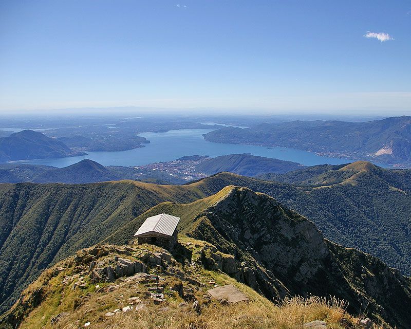
Great itinerary to do by MTB characterized with beautiful landscapes: Lake Maggiore, Lake of Orta, the Po Valley, the Mount Rosa and the Swiss Alps.
The route:
From the Istituto Auxologico di Piancavallo you will reach Colle by the road. On the left is the start of the military road of the Cadorna Line, recently restored. Continue up to Pian Darla, then Pianpuzzo where you go on the north side, to reach the locality Archia. Go on until you reach passo Folungo where the military road clearly changes inclination to go up with a series of bends to Pian Vadà. From here the road becomes a comfortable flat trail leading to Piè Zeda (where you leave the bike) and after a steep trail you reach the top of Mount Zeda, one of the most panoramic place of the Lake Maggiore. Go back by the trail you took forward up to passo Folungo. Take the military trail that goes down smoothly to alpe Biogna and then back to Pianpuzzo. You will then be back again on the north side and on the forest track you reach Pian d'Alpe from where, across a trail with a beech forest you will arrive in Colle. Here, from the fountain, you can take e trail towards the top of the Morissolo, a beautiful balcony on the Lake Maggiore, where you will have the possibility to visit the fortified galleries of the Cadorna Line. Then you are back again in Piancavallo taking the easy flat military trail, with admirable architectural stone elements.
Useful information:
In Piancavallo a service of free bike-sharing is offered. At the moment (2014) there are16 MTB and a total of 60 MTB are expected (2015)
Informazioni: https://www.facebook.com/CadornaBikePark?ref=hl
Where to eat:
La Dislocanda – Hotel Restaurant – Strada Cadorna, 26, 28824 - Manegra di Oggebbio, VB, (IT) tel. +39 0323 587173 www.dislocanda.it
La baita di Piancavallo – Bar and Restaurant – Via Luigi Cadorna, 91 – 28824 – Piancavallo di Oggebbio, VB, (IT) tel. +39 0323 587396 www.ristorantebaitadipiancavallo.com/