Departure point:
Sant’Agata – Frazione Cannobio (VB), Italy
How to get there:
By bus: bus for Cannobio, line Verbania – Brissago. Timetables: www.vcoinbus.it
By boat: boat for Cannobio, line Verbania – Cannobio – Locarno. Timetables: www.navigazionelaghi.it
By train: Re station, Vigezzina Railway. Timetables: www.vigezzina.com
By car: A26 motorway in direction of Gravellona Toce, exit for Baveno. Follow in direction Verbania S.P.167 up to Fondotoce, then S.S.34 del Lago Maggiore up to Cannobio.
General Description:
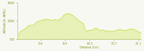
Three-day itinerary for experienced hikers in the first part of which you will cross steep valleys and panoramic ridges on the upper part of Lake Maggiore. In the second part, the itinerary is easier and follows the old Borromean Route – San Carlo Circuit.
The route:
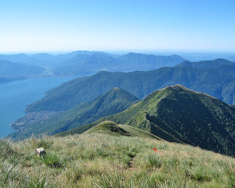
In Sant’Agata you go up the Oratory of S. Luca and then for the pasture of Marcalone, from where either on a trail or a forest track, you will reach Rombiago from where, with a short deviation you can go up to the Mount Giove, a suggestive viewpoint. From Rombiago continue for Scierz and then for the top of the mount Faierone, the peak Fronzina and passo Percadugine until you arrive at the highest peak of the itinerary, the Mount Limidario, as well known as Mount Gridone, panoramic peak overlooking Lake Maggiore, at the border between Italy and Switzerland. From here continue down the ridge in direction South-West, passing through the alps La Quadra and of Spoccia up to 1334m high, a place called “the 3 borders. From here it is possible with a short deviation to reach Le Biuse where you will find the refuge Rifugio delle Nevi. Back to the “3 borders” you reach Spoccia on an easy flat trail up to Orasso. Then follow the itinerary of the bottom of the valley following the Borromean route – San Carlo Circuit, this itinerary allows you to go up the entire valley Cannobina with informative panels, panoramic footboards and memorial stones inviting to the discovery of the numerous historical, natural and cultural aspects of the territory, arriving to Orasso, Cursolo, Finero. From here you cross in the Vigezzo Valley and along the route Finero-Pian di Sale you reach Re, where is the famous sanctuary dedicated to the Madonna del Sangue.
Useful information:
The route especially in its first part to the mount Limidario-Gridone, is difficult to follow with its high difference in level, so you need to be very experienced hikers. A beautiful alternative itinerary of the stop Le Biuse-Orasso that goes up to the Bocchetta del Fornale and thus the crossing of the ridge along the difficult rocks of the Gridone up to Pluni, to go down from here to Orasso. From Re you can reach Locarno (CH) with the Vigezzina railway, then back to Cannobio by boat with the Navigazione Lago Maggiore or by bus.
Where to eat or stay :
- Agriturismo “da Attilio” - Marcalone di Cannobio – 28822 Cannobio, VB, (IT) – tel. +39 338 3413423 www.bbmarcalone.it
- Rifugio delle Nevi – Ass. Cult. “ghiro felice” loc. Le Biuse di Cavaglio Spoccia – 28825 Cavaglio Spoccia – tel. +39 333 624 1316
- Albergo Belvedere – Hotel Restaurant Bar – Via Cursolo, 8/a – 28827 Cursolo Orasso, VB (IT) tel.+39 0323 77136 www.belvedereorasso.it