Departure point
The square in front of Lake Mergozzo.
How to get there
Exit the SS33 Sempione highway at Mergozzo and head to the car park at the entrance to the village.
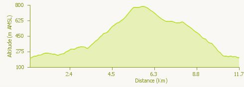
The route
From the square on the lake front, follow the signs and head into the village to the start of a mule track leading to Oriola.
Pass the fork and then, following the signs along a good mule track, an old chapel. You then reach an unsurfaced road which you should follow for a short stretch before regaining the mule track and following the information panels regarding the historical "Montorfano: the mountain with a heart of granite” trail.
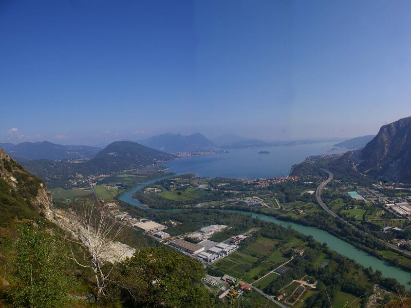
Having reached a metalled road, you climb to the village of Montorfano, passing the cemetery before reaching the attractive village. As you explore the village you will find a protestant church, a catholic church dating from the 12th Century and charming houses. There is also a trattoria offering local dishes and a viewpoint providing a fine view over the mouth of the Toce river.
As you proceed along the path climbing to the summit of Montorfano, you will pass a rock climbing wall, the ramp to an old quarry and a number of viewpoints with benches.
From the summit you walk back down along the good Linea Cadorna mule track, reaching a small level area offering various views. From the explosives stores you descend to the left as far as the small barracks. From the barracks you head right along a good footpath that, after having passed a disused quarry, reaches the village of Mergozzo.
Before returning to the departure point we suggest that you explore the village lanes with their towers, the house of the Knights of Malta and the church.
Useful information
Bus: Domodossola / Verbania route.
Food and drink:Trattoria “Belvedere” in the village of Montorfano (Tel. +39 0323 80134).