Starting point
The itinerary starts from the old boat station of Intra, on the Piedmont shore of Lake Maggiore.
How to get there
The starting point can be reached via autostrada A26, exit at Gravellona Toce
Main features of the route
This tour is highly scenic, taking you through the wonderful landscape of the Vigezzo Valley (known as the “Painters’ Valley”), the Ossola Valley, and Val Grande, the largest wilderness area in Europe.
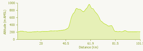
This is a very demanding round trip, both for its length and the difficulties presented by the 20 km of road through the Cannobina Valley.
The route
Leaving Verbania Intra, go to Cannobio on the State Road (SS) 34. This is a road of busy traffic and is rather narrow in places, but the views are spectacular, from Lake Maggiore and the villages on the lake side to the surrounding mountains.
Before entering Cannobio turn left into the Cannobina Valley. The ascent begins at the turnoff for Traffiume, which you pass on your right. Go on up the winding road to the left of the River Cannobino, as far as the bridge a few hundred metres from Nivetta.
Proceed up the road to the right of the river, past Lunecco and Ponte Falmenta. From here the road leaves the river bank and goes on across a series of bridges over streams rushing down from the south side of Monte Gridone.
After the turnoff for Orasso and Airetta the road goes through a tunnel; from here the road levels out for a few kilometres, as far as the pretty village of Finero. You now cross the whole of the “Painters’ Valley”, slightly uphill; when you get to Druogno the long, steep descent to the turnoff for Masera begins. Turn left for Croppo di Trontano, on the valley floor of the River Toce. The road continues on the level; you will go through the villages of Beura, the historic ancient burgh of Vogogna with its Visconti castle and fortress, Premosello Chiovenda and Cuzzago.
When you come to a roundabout go straight on through Nibbio, Bettola, and Candoglia to Mergozzo, where the road slopes down to the lake side. Go back along the side of picturesque Lake Mergozzo to Fondotoce. Turn left at the junction to complete your tour back to Verbania Intra.
Useful information
Buses run from Intra to Cannobio – see VCO in bus
The Centovalli train runs from Domodossola through the Vigezzo Valley to Locarno.
Refreshment facilities: there is a wealth of bars and restaurants in Intra, Ghiffa, Cannero Riviera, Cannobio, Finero, Malesco, S. Maria Maggiore, Druogno, Beura, Prata, Vogogna, Premosello Chiovenda and Mergozzo.