Starting point
Bracchio (300 mt a.s.l.)
How to get there
By car
Autostrada A26 to Gravellona Toce; the motorway continues as a dual carriageway. Exit at Mergozzo, then continue to Candoglia/Mergozzo/Bracchio.
By train
The nearest railway station is Verbania Fondotoce, on the Domodossola – Milan line.
By bus
See the website VCO in bus
Short description of the route
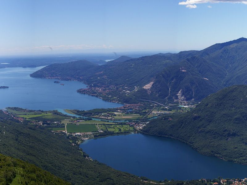
The itinerary takes in a corner of the Ossola Valley and of the hinterland of Verbania. It offers marvellous views of the stunning scenery surrounding Lake Mergozzo and Val Grande.
Mergozzo has a Roman castrum, the house of the Knights of Malta, and a medieval centre; nearby there are the famed Candoglia marble quarries – this marble was used in building Milan Cathedral – and one of the demanding access routes to Val Grande, the largest wilderness area in Europe.
The route
Starting from the centre of Bracchio, go past the “circolo” bar and you come to a square. From the left side of the square go up to the top of the village, where, after a chapel, there is the turnoff for Boscopiano.
Go up the fine mule-track leading to the Eremo (Hermitage) of Vercio. Halfway along this path, near a pretty little chapel, the view is already superb: lakes, mountains and the village below. Continue past some alpeggi to the entrance to Alpe Vercio.
At the entrance to the Hermitage a detour to the left takes you to see the oratory church. Go back for a walk round the Alpe, stopping at the cross to see the view opening up over the lakes.
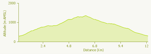
The path continues to ascend from the picnic area, arriving after a series of bends at the Colma (highest point) di Vercio. From the Colma the track goes on up to the peak of Monte Faiè, from where the spectacular view takes in the plain of the Toce estuary, Lake Maggiore, Lake Orta, and the mountains of Val Grande.
Go down along the nature trail of the Val Grande National Park to a col from where a path leads to Corte Buè. Take the path down to the right to reach Ompio, where there is a mountain hostel, the Rifugio Fantoli, an excellent place for a meal and a drink.
Continue to Alpe Ruspesso, initially between high drystone walls and then through chestnut woods. Crossing the surfaced road several times you come to the Chapel of Erfo. The path back to Boscopiano and Bracchio starts from the road.
Useful information
Bus: Buses leaving Domodossola international station for Verbania stop at Mergozzo. From here you can get to Bracchio following the sign saying “A52” (25 mins).
Refreshment facilities
Rifugio Fantoli (Andrea Righes +39 340 5783883 - www.rifugiofantoli.it - info@rifugiofantoli.it).