Starting point
The Rifugio Campiglio, at Alpe Pradecolo.
How to get there
You get to Alpe Pradecolo following the surfaced road going up from Luino to Dumenza, Due Cossani, Agra and Curiglia (17 km).
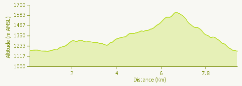
General features
The route is punctuated by breathtaking views, taking in Lake Maggiore and Lake Lugano, as well as the peaks of the Pennine and Lepontine Alps.
The route
Starting from the mountain hostel the path enters a beech wood and goes up to a dirt track with views of the lake – Luino and the castles of Cannero – and Monte Rosa. Continue to Alpe Pian di Runo, where there is a spring.
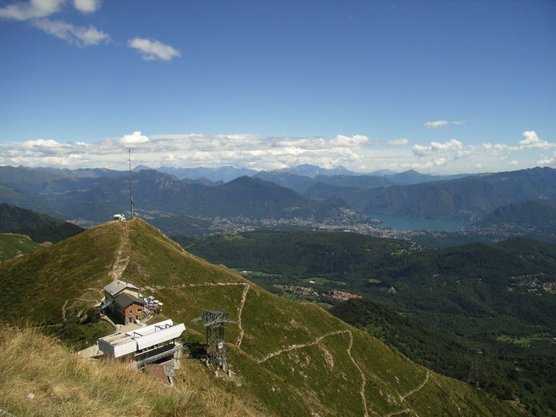
Farther on you get to a broad ridge, and the view opens out increasingly; when you get to the top of Monte Lema there is a 360° panorama taking in Lake Lugano, Lake Maggiore, the Varese foothills, the Pennine Alps and the Lepontine Alps.
Go down to the cableway station and continue in the direction of the Forcola d’Arasio; a detour to the left takes you to Alpe Arasio. Take the path towards Alpone through a fine beech wood.
When you get to Alpone, where there is an agriturismo and a small mountaineering hut, you go up a short distance to the oratory church of the Madonna della Guardia.
Not far above the oratory there are signs indicating the way to Pradecolo; the route here is more or less over level ground, sometimes downhill.
Useful information
From the province of Verbano Cusio Ossola you can reach Luino by car ferry (Intra-Laveno).
Refreshment facilities
Rifugio Campiglio +39 0332 573109 - Rifugio Monte Lema 0041 919670013053 - Madonna della Guardia Hut +39 0332 568421