Starting point
Car park at San Bernardo in Bognanco (1,628 mt) in front of the Rifugio (mountain hostel).
How to get there
By car
Autostrada A26 to Gravellona Toce, then the road continues as a dual carriageway to Domodossola, where you exit. Take the Provincial Road (Strada Provinciale) 68 for Valle Bognanco/Graniga/San Bernardo.
By train
The nearest railway station is Domodossola. Buses leave here for Bognanco.
By bus
Domodossola – Bognanco line (Comazzi bus company)
Short description
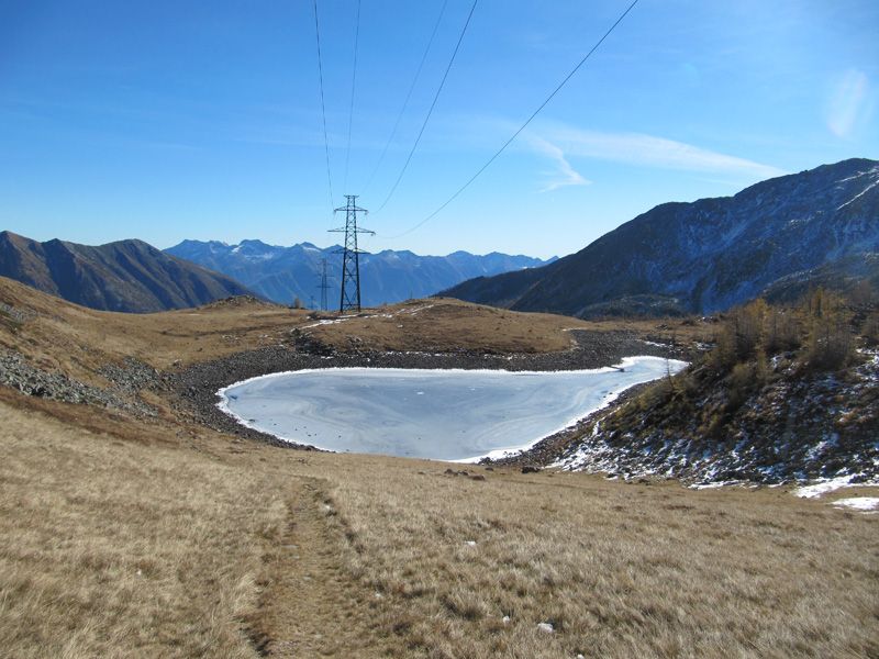
The Bognanco Valley is known as the “Valley of the Hundred Waterfalls”, due to the many lakes and bogs whose water feeds streams that turn into waterfalls lower down the valley.
Lake Monscera lies in the high part of the Bognanco Valley at 2,072 mt a.s.l., in a moraine depression in the high glacial valley of the Rasiga Stream. It has an area of 5,600 sq mt.
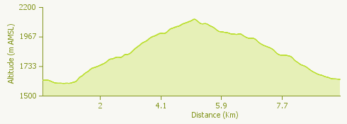
The route
From the car park outside the San Bernardo mountain hostel take the semi-private road that crosses the Rasiga stream and goes up by steep bends through spruce and alder woods, which increase the beauty of the mountain scenery.
The road then becomes a trail and starts to climb to a wide expanse of peatbog. Go on to the little lake Ragozza (1958 mt) nestling among the larches, then go down to the Rifugio Gattascosa.
From the hostel the trail continues as a wider track. After passing two more peat bogs, turn left onto the path to Lake Monscera, and from here to the Moscera Pass.
From the pass you go down to the where the road turns off to the Agro Lakes, a short distance above the large cattleshed on Alpe Monscera. Continue on the track, passing on your left a second turnoff to the Agro Lakes, and then a path leading to the Paione Lakes, to arrive at the Rifugio del Dosso.
A surfaced road leads to the fork for the Variola Lakes; take the wide path to the left that runs alongside this road. Just below San Bernardo the surfaced road begins again, where there is a large boggy area; you then turn off onto the path leading back to your starting point.
Useful information
Bus: Buses leave the railway station of Domodossola for Bognanco. You then have to continue on foot for Gomba/San Bernardo, following the signpost “D0” (1 h 45 mins.)
Refreshment facilities: Rifugio San Bernardo, tel. +39 334 1397905, +39 347 2757823, www.rifugiosanbernardo.it, Rifugio Gattascosa, tel. +39 328 3151669, www.rifugiogattascosa.it - Rifugio Il Dosso, tel. 0041 798620936 - +39 335 6431417 www.rifugioildosso.it