Departure point:
Ponte Formazza (VB), Italy
How to get there:
By train: Domodossola Station, Ferrovie dello Stato. Timetables: http://www.trenitalia.com/; www.ffs.ch
By bus: bus for Ponte Formazza, line Domodossola – Cascata del Toce. Timetables: www.vcoinbus.it
By car: A26 motorway to Gravellona Toce, then SS33 Sempione, after Domodossola take the exit for Valle Formazza and continuing on SS 657 you reach Ponte Formazza.
General Description:
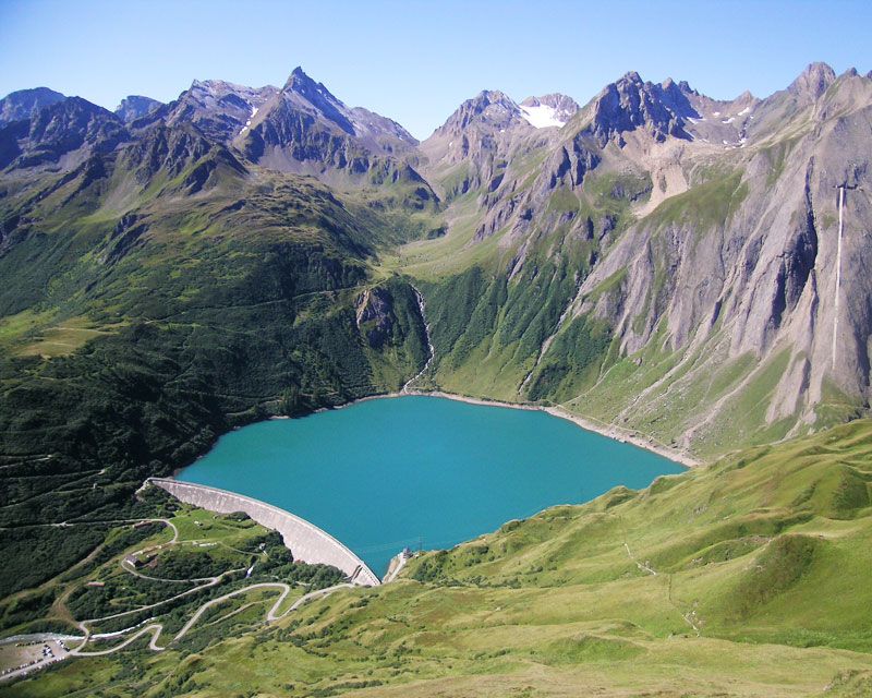
The Toce waterfall, with a jump of 143 m, has been celebrated by writers, travelers and painters and is one of the wonders of Ossola. On top of the waterfall there is the historic hotel from 1863, centre of the tourism of the Alps from early century. In the plain of Riale, you will find the trail called Sentiero Mario Rigoni Stern in direction of Alpe Furculti. The trail commemorates the presence of the writer in Formazza during winter 1938-1939 in the occasion of the skiers’course of the Alpine Military School.
The route:
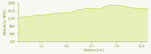
From the Town Hall square of Ponte, follow indications for trail G00d, a variant of the route” Via del Gries”. Just before the ENEL power plant cross the bridge and start climbing for a large track that on the upper part of Brendo becomes a trail until the beginning of Grovella. From here the track becomes steeper and to get to Canza you need to go up a crest (“il Cree”). Arrived in Canza, do not cross the river but continue on the route along the river which becomes a steep but short trail after a while and crosses off another crest to reach Sottofrua. From here continue following the indications for Riale, first for a short distance on a dirt track, then on a large trail leading to a nice bridge right at the foot of the waterfall. Cross the bridge and go on a nice mule track that goes up like a stepped trail to the top of the waterfall. Once arrived at the top, continue up to Riale along the road or on the old mule track (trail G00). In front of theHotel Aalts Dorf of Riale, a sign and a commemorative plaque indicate the start of the trail “Sentiero Mario Rigoni Stern”. The track goes up to the plains of Furculti and comes to cross the pasture trail for Alpe Nefelgiu that you follow in direction of Lago di Morasco. You will pass in front of the Bim See refuge and then walk back to Riale along the road.
Useful information:
Important: you can go by bus to Riale and the Toce waterfall only with the summer timetables from June to mid-September. The winter timetables end in Ponte.
Where to eat:
Bar Ristorante Cascata Toce Località Cascata del Toce, Formazza, VB, (IT) tel +39 0324 634130
Ristorante Aalts Dorf Località Riale, Formazza, VB, (IT) tel. +39 0324 634355 http://www.aaltsdorf.it
Rifugio Bim-Se Località Morasco, Formazza, VB, (IT) tel. +39 339 5953393 http://www.rifugio-bimse.it
Ristorante Walser Schtuba Località Riale 28863 Formazza, VB, (IT) tel. +39 (0) 324.634352 - cell. +39 339 3663330 http://www.locandawalser.it