Departure point:
Ornavasso (VB), Italy
How to get there:
By train: Ornavasso Station, Ferrovie dello Stato. Timetables: http://www.trenitalia.com/; www.ffs.ch
By bus: bus for Ornavasso, Line Domodossola - Omegna : www.vcoinbus.it
By car: A26 motorway to Gravellona Toce, then SS33 Sempione, exit for Ornavasso.
General Description:
Circular itinerary to discover the Cadorna Line, a complex of military fortifications dating back to World War I which was aimed to defend the Northern border of Italy with Switzerland. The trail is also characterized by important examples of popular religiosity.
The route:
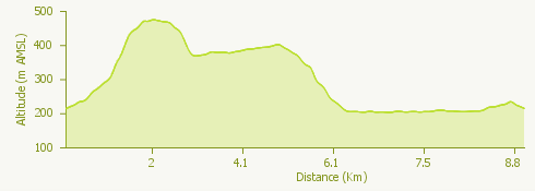
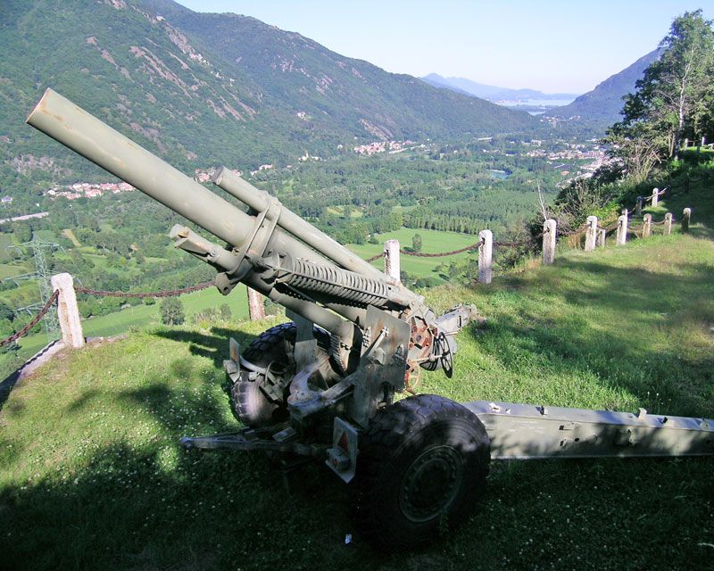
From the station, cross the town center reaching via Gasse, in the higher part of the town. Take the mule track going up to the church then follow along the “Strada dei pellegrini” (the pilgrims’ road), the Via Crucis going up to the Santuario del Boden, the sanctuary (Boden = plain, in the Ornavasso Walser language). Placed in a dominant position above the town, the sanctuary is still a popular destination (it honors the apparition of the Madonna on September 7th 1528 ). From the sanctuary take the road going down to Ornavasso and at the first turn enter the flat military road leading to the old marble quarry of the Boden, used to build Milan’s Duomo. Continuing along the military road you will reach the Forte di Bara, the fort, defensive work belonging to the Cadorna Line, consisting in a series of pitches supported by stone walls, main dam of the Stretta di Migiandone, the narrowest place of the Toce valley, main access route from the lakes to the passes of Ossola. From the fort of Bara, go down along the military track, built to access to the strategical Punta di Migiandone, then you arrive at the bottom of the valley in a large square characterized by the presence of a big cannon. From here, by small country roads you go along the rocky walls for climbing until you arrive to the small lake called Laghetto delle Rose. Then by internal roads you cross again the town of Ornavasso up to the station.
Where to eat:
Antica trattoria del Boden, Piazza Boden 11, Ornavasso VB, (IT) Tel. +39 0323 835976 www.trattoriaboden.it
Ristorante Lago delle Rose, Via Pietro Iorio, Ornavasso VB, 8IT) Tel. +39 333 9829810, www.lagodellerose.it