Departure point:
Villadossola (VB), Italy
How to get there:
By train: Villadossola Station, Ferrovie dello Stato. Timetables: http://www.trenitalia.com/; www.ffs.ch
By car: A26 motorway to Gravellona Toce, then SS33 of Sempione, exit for Villadossola.
General Description:
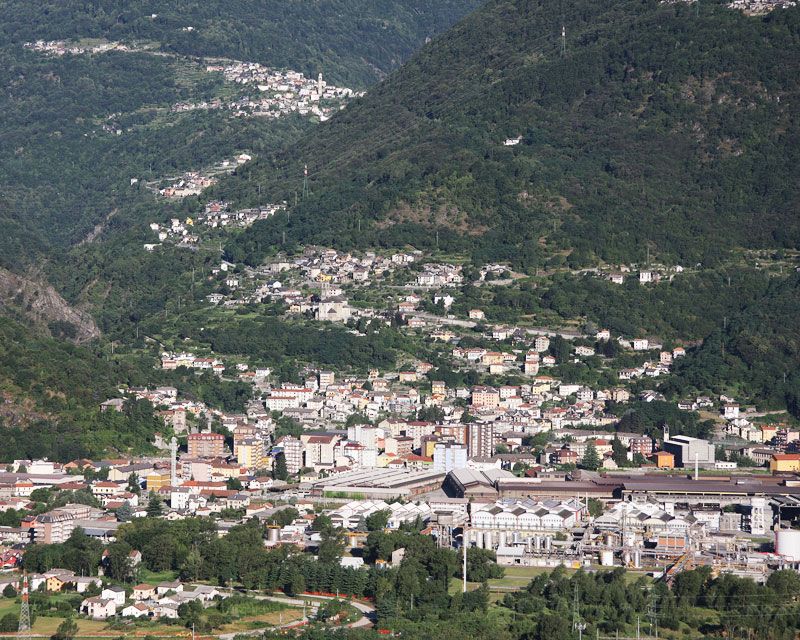
Steel industrial center of Ossola, at the foot of the Antrona Valley, Villadossola developed in the nineteenth century thanks to iron mines of Ogaggia and exploitation of falls of water to produce electricity. This was also a valley of passage and the itinerary develops along the “Strada Antronesca” route, old trade route connecting with the Saas Valley in Switzerland.
The route:
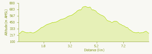
From the station go up via Fabbri until the roundabout. Nearby the Chapel of San Rocco go up the flight of steps leading to the ruins of the oratory of San Maurizio al Sasso, built in the eleventh century. Stay on the road passing Villa Lena, for many years residence of the heirs of Filippo Maria Ceretti who founded in 1796 the company of the same name. You will then arrive at the Church of the Beata Vergine Assunta in Piaggio. After the bridge for Maglietto, where once stood a forge iron and a hammer, you will reach piazza IV Novembre. Here starts the mule track of the Antronesca Route, that you will follow until the Noga, crossing the village. Leaving the Antronesca route take the mule track on the right for Daronzo. Once you crossed the village, the track leads to the road for Sogno, that you follow, except on short stretches, up to the old village. From the oratory of San Giovanni Evangelista, cross the entire village to arrive at the museum of rural life (Museo della Civiltà Contadina). For the way back take again the road up to the junction for Varchignoli and then, on the track, you reach Casa dei Conti. A deviation leads to Boschetto where the museum of origins (Museo delle Origini) and an inn have been made. Continuing instead along the track, you reach the road and after about 350m, you take again the track on the right, going down to Noga and to Villadossola.
Useful information:
For information and specialized educational visits for schools contact:
• CAI Villadossola – www.caivilladossola.net
• Aree protette dell’Ossola – www.areeprotetteossola.it
• On the website of the Ente Aree Protette dell’Ossola (http://www.areeprotetteossola.it/it/l-azione-del-parco/educazione-ambientale/materiali-didattici-verso-la-valle-antrona) educational materials are available to deepen the subject on the area of Domodossola – Villadossola – Valle Antrona with a particular reference to the places where this itinerary develops.
Where to eat:
La Tavernetta
C.so Italia, 4, 28844 Villadossola, Italia
Tel. +39 339 6511980
http://www.tavernettaristorante.com