Departure point:
Orta San Giulio (NO), Italy
How to get there:
By train: Orta-Miasino-Legro Station, Ferrovie dello Stato. Timetables: http://www.trenitalia.com/; www.ffs.ch
By bus: Bus for Orta San Giulio, line Domodossola – Omegna and Line Novara-Borgomanero-Omegna-Domodossola. Timetables: www.vcoinbus.it
By car: from North A26 motorway exit Gravellona Toce. Follow direction for Omegna SR 229. From Omegna follow direction Orta San Giulio.
From South: A26 motorway, exit Borgomanero. Follow the road SP229 direction Orta San Giulio.
General Description:
Two/three days hiking itinerary in a Unesco World Heritage site, protected villages and breathtaking panoramas over the Lake Maggiore.
The route:
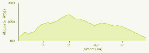
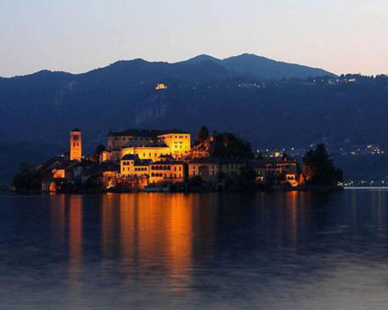
The itinerary develops itself around Orta San Giulio, elected among the most beautiful villages of Italy (“Borghi più belli d'Italia”),and the Sacro Monte di Orta, Unesco World Heritage. Follow the first part of the itinerary called “Anello Blu” of the “Quadrifoglio di Ameno” reaching shortly Legro, where are 45 wall paintings inspired by films set in the territory. After a stretch on the road, then a track, you reach Ameno ” sustainable village of Piedmont” , from where you take in the North East direction to reach Coiromonte. Continue on the trail in direction of Monte Mottarone, enjoying the wonderful view on Lake Maggiore, Lake of Orta, the Po Valley, and the Alps from Monviso to Monte Rosa up to Mischabel. On the Mottarone you can stay overnight if you didn’t choose to stop in one of the villages before this place. From the Mottarone, on the second day, you continue down still on a panoramic trail, passing from Mount Zughero, the slopes of Mount Camoscio until you arrive in Baveno, on the banks of Lake Maggiore. You can make the itinerary shorter by the cableway going down from the Mottarone up to Stresa, and then continue to Baveno by train or boat.
Useful information:
Sacred Mountains of Piedmont and Lombardy, Unesco World Heritage: www.sacrimonti.net; whc.unesco.org/en/list/1068
Most beautiful villages of Italy Borghi più belli d’Italia: www.borghitalia.it
Sustainable villages of Piedmont: www.borghisostenibili.it
From Stresa you go back to Baveno by boat with the Navigazione del Lago Maggiore. Timetables: www.navigazionelaghi.it. Or by train with the Ferrovie dello Stato. Timetables: http://www.trenitalia.com
Timetables and information for the cableway Funivia Stresa-Alpino-Mottarone: www.stresa-mottarone.it
WARNING: Stresa-Mottarone cable car temporarily not working
Where to eat or stay:
- Omnidiet – Hotel Restaurant Bar – Via Monte Falò, 8 – 28011 Coiromonte di Armeno, NO (IT) tel.+39 0322 999009 www.omnidiet-hotel.com
- Hotel Miramonti – Hotel Restaurant – Località Mottarone Vetta – 28838 Stresa, VB (IT) tel.+0039 0323 9+924822 +0039 338 4601697 www.miramonti-mottarone.it
- Casa della Neve – Hotel Restaurant – Località Mottarone – 28838 Stresa, VB (IT) tel. +0039 0323 923516 +0039 335 7636962 www.casadellaneve.it
- Hotel EDEN – Hotel Restaurant – Località Mottarone Vetta – 28838 Stresa, VB (IT) tel. +0039 0323 924873 +0039 380 7107300 www.edenmottarone.it