Departure point:
Orta San Giulio (NO), Italy
How to get there:
By train: Orta-Miasino-Legro Station, Ferrovie dello Stato. Timetables: http://www.trenitalia.com/; www.ffs.ch
By bus: Bus for Orta San Giulio, line Domodossola – Omegna and Line Novara-Borgomanero-Omegna-Domodossola. Timetables: www.vcoinbus.it
By car: from North A26 motorway exit Gravellona Toce. Follow direction for Omegna SR 229. From Omegna follow direction Orta San Giulio.
From South: A26 motorway, exit Borgomanero. Follow the road SP229 direction Orta San Giulio.
General Description:
Easy circular hiking itinerary to discover the Sacred Mountain of Orta, declared Unesco World Heritage and elected among the most beautiful villages of Italy.
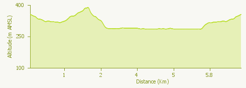
The route:
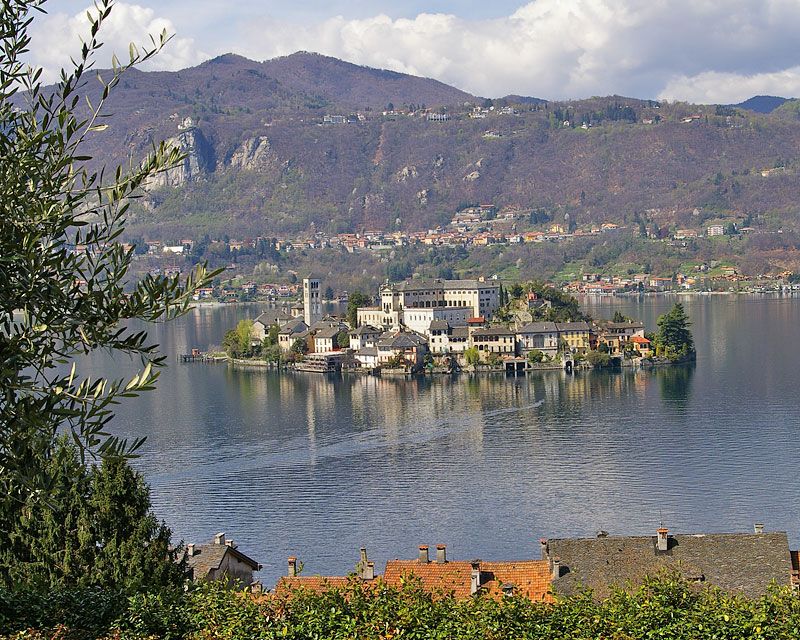
From the station go along via Lunati, thus follow indications for the center, go down Via Marconi until you reach the roundabout in front of the particular Villa Crespi. Go straight up to the car-park of the Tourist Office at the beginning of the panoramic road for Orta. On the other side will start the climbing road leading to the Sacro Monte, devotional complex consisting of twenty frescoed chapels with natural size statues illustrating the life of St. Francis of Assisi. With a nice shaded descent you get to the square of the cemetery of Orta and the Church of San Quirico. Going on along via Gemelli you reach piazza Motta, the center of Orta, where leave the boats for the San Giulio Island, dominated by the Romanesque basilica, the bishop’s palace and the Benedictine Abbey. From piazza Motta you go along via Olina, via Bossi, via Gippini, via Motta until you reach the Villa of the same name, where starts a nice pedestrian trail that goes along the lake (via 11 Settembre). Once passed the end of Punta Movero, the trail gently follows the curve of the peninsula until its end, where, turning right, you go up again to the panoramic road near the Tourist Office and then reach shortly the railway station.
Useful information:
Sacri Monti del Piemonte e della Lombardia, Sacred Mountains of Piedmont and Lombardy, Unesco World Heritage: www.sacrimonti.net; whc.unesco.org/en/list/1068
Most beautiful villages of Italy, Borghi più belli d’Italia: www.borghitalia.it
Service of the Navigazione Lago d’Orta: www.navigazionelagodorta.it Tel. +39 345 5170005
A touristic train allows you to reach the most characteristical places of Orta: the Sacro Monte, the village of Legro with its paintings and the square Prarondo: www.treninodiorta.it tel. +39 339 5313589