Departure point:
Bognanco (VB), Italy
How to get there:
By train: Domodossola Station, Ferrovie dello Stato. Timetables: http://www.trenitalia.com/; www.ffs.ch
By bus: bus for Bognanco, line Domodossola - Bognanco. Timetables: www.vcoinbus.it
By car: A26 motorway to Gravellona Toce, then SS33 Sempione, exit for Domodossola. Follow for Val Bognanco up to Bognanco Fonti.
General Description:
This hiking itinerary goes halfway up the slope from Villadossola to the Sacro Monte Calvario (Unesco World Heritage) and continues up to Bognanco Terme. A trip on historical paved stone roads that allows you to understand the landscape of old agrarian economies in the mountains.
The route:
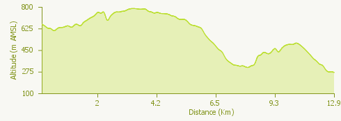
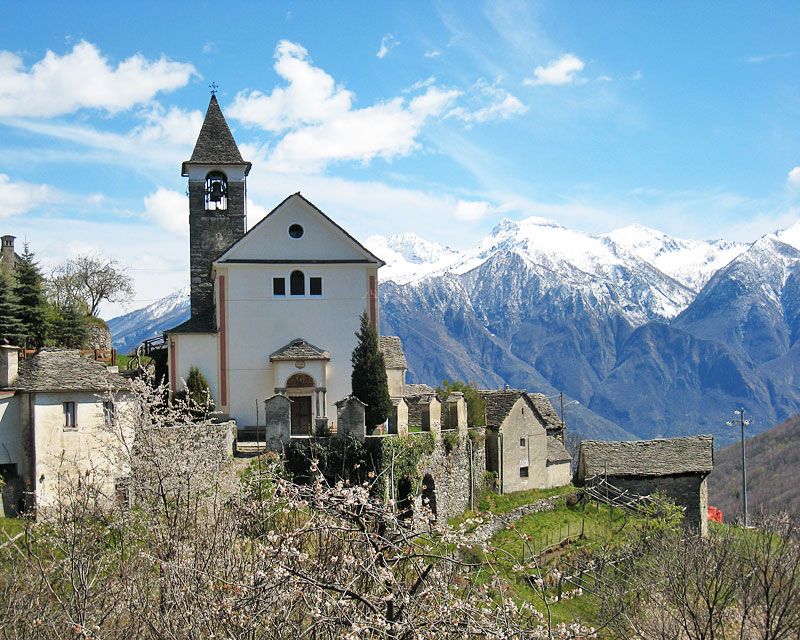
From Bognanco Fonti take the trail D0 (Via del Monscera) towards Ca’ Monsignore, that you reach after passing on a nice stone bridge the gorge of the stream Rabianca. The trail continues first halfway up the slope then going down steeply up to the torrent that you cross on a small stone bridge and goes up shortly to the Oratory of the Dagliano. Continue going up passing on the left side of the church walking through a group of mountain houses. Continuing on a nice track you arrive to Monteossolano. Leaving the church dedicated to San Gottardo you go on an asphalted stretch reaching Pregliasca. From here, first halfway up the slope on a road fire, then on a steep track in the woods you go down to Cisore. On a nice track you reach Mocogna, then on an asphalted road up to Castanedo, situated on the opposite side of the valley. From here on a large track you arrive to Vagna (Maggianigo). Around Vagna many chapels and oratories spread in the woods telling the local popular religiosity, celebrated today on the occasion of the procession of the “Processione del Bambin” (June) with the traditional baskets called “cavagnette”. You will shortly arrive up to Croppo and continuing first on a trail in the woods, then on a track, you reach Motto and the Chapel of Marisch. In the end on a nice stepped mule track you go down to the Sacro Monte Calvario ( Unesco World Heritage). Along the shaded Via Crucis you go down to the old town of Domodossola and you will soon reach the railway station.
Useful information:
Trail D00. The itinerary coincides with the route of the “Via del Monscera” natural extension on the Italian territory of the “Stockalperweg” route.
Where to eat:
Circolo di Monteossolano Fraz. Monteossolano, Domodossola VB, (IT) tel.+39 335 6749402