Departure point
Sant’Agata car park
How to get there
From Cannobio head towards Locarno and take the road that climbs towards Sant’Agata.
The route
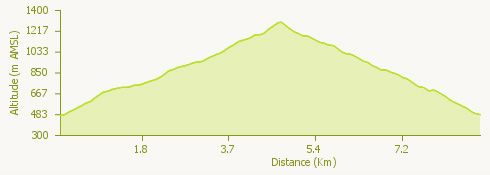
From the car park located shortly before Sant’Agata, take the mule track leading to the square in front of the church. From the square the route enters the village and then climbs through the woods before reaching the Oratorio di Santa Lucia in around 40 minutes.
From the Oratorio, the route proceeds in places on a paved mule track but largely along a footpath. Having passed the ruins of an alpeggio, or hill farm, you reach the fork heading to the agriturismo; leaving the agriturismo on your right the route climbs gently to a chapel (in around 40 minutes).
Leaving the route that descends to Cavaglio on your left, take the path that climbs to the Alpe and the Rifugio Zabò (50 minutes). Gently climbing along an unsurfaced road, you reach the fork for Monte Giove (5 minutes) and from here the summit (20 minutes).
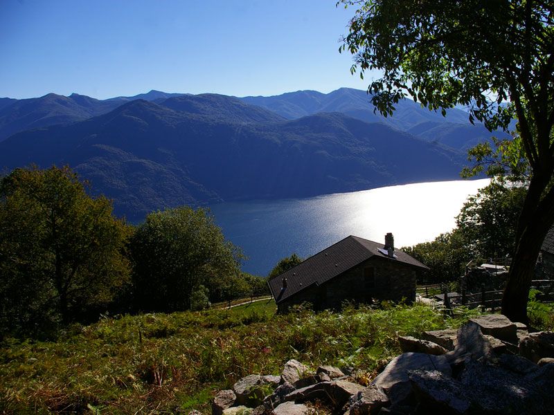
The summit of Monte Giove provides a 360° view out over Lake Maggiore, the Magadino plain, Locarno, Bellinzona, Brissago with its islands, the southern part of the lake, Cannobio and the whole of the Valle Cannobina.
Returning to the fork, take the path that descends on the right in the direction of the Alpe Marcalone agriturismo. The route begins with a series of steps then develops into a path and an unsurfaced road.
You may enjoy a fine panorama from just above Alpe Marcalone before descending to the agriturismo in around 50 minutes. You then descend across the meadows before reaching the fork on the previous path (15 minutes). From here you may reach the village of Sant’Agata.
Useful information
Bus: There are morning only services between Cannobio and Sant'Agata. On the return leg you should take the Sant’Agata – Traffiume – Cannobio mule track (45 minutes).
Food and drink: Agriturismo “Da Attilio”, Alpe Marcalone – Trattoria della Volpe, Sant’Agata (tel. +39 0323 71396)