Departure point
The route starts from the hard standing in front of the Cascata del Toce hotel.
Significant aspects of the route
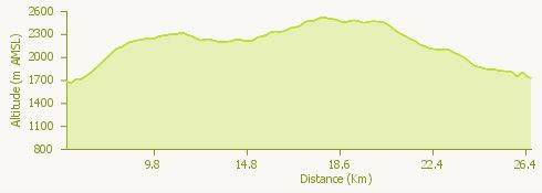
This fairly demanding trail features spectacular panoramas taking in lakes, glaciers and major mountains. The route follows unsurfaced roads and footpaths providing easy walking in certain sections but which are more challenging and exposed in others.
How to get there
Autostrada A26, Valle Formazza exit. Follow the valley up to the hotel at the Cascata del Toce waterfall (32 km from the autostrada exit).
The route
From the parking area in front of the Cascata del Toce hotel follow the metalled road that climbs gently as far as the fork for Riale; from here take the ENEL (energy company) unsurfaced road that climbs to the Toggia dam (medium steepness).
After passing the Rifugio Maria Luisa, you will find a very steep short stretch leading to the dam itself; from here follow the shore of Lake Toggia for around 3 km, reaching the old Passo San Giacomo barracks.
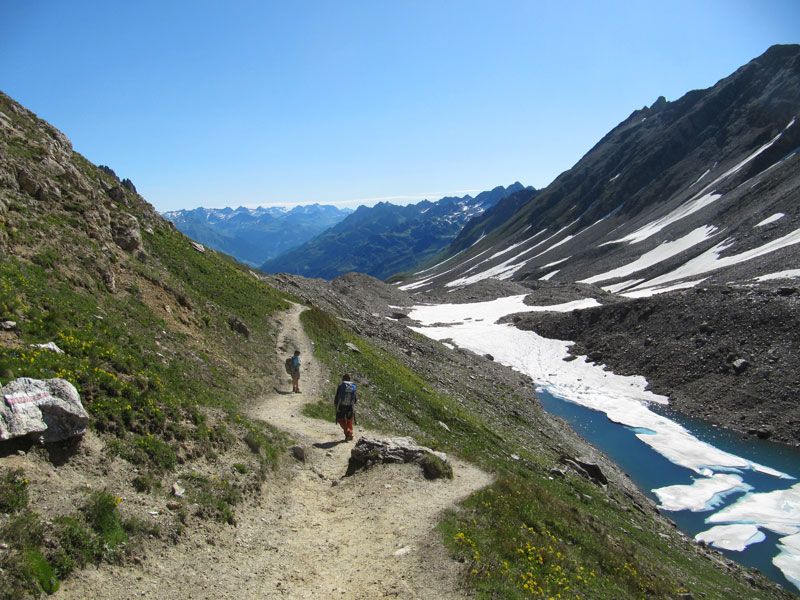
From Passo San Giacomo, take the broad footpath on the left that after a short climb begins to descend steeply to the Alpe below. Head left in the direction of the Passo Novena valley. From here the footpath is descends gently but is exposed and therefore requires attention.
The footpath leads to a level area and then a short climb to the Capanna Corno Gries. From the Capanna or hut you climb, alternating footpaths and scree slopes, through to the Corno saddle with views of the Lake Gries, the Blindenhorn and the Arbola.
You then descend along a good footpath to the Passo del Gries, reaching a panoramic viewpoint and the small Rifugio/Cappella del Gries.
The pass marks the beginning of the steep descent towards the Bettelmat meadows after crossing which you reach the unsurfaced road (currently impracticable through to Morasco). Shortly afterwards the route bears right, following the footpath that descents to the parking area in front of the Enel Sabbioni ropeway. From the hard standing you follow an easy unsurfaced road around Lake Morasco as far as the dam. Via the metalled road you then reach the underlying Riale valley and shortly afterwards the point of departure.
Useful information
Bus: from the station in Domodossola for Formazza (currently unequipped to carry bicycles).
Food and drink:
Albergo della Cascata (Tel. +39 0324 63013), Ristorante Le Alpi (Tel. +39 338 3448489), Ristorante Pernice Bianca (Tel. +39 0324 63200), Aalts Dorf, Riale (Tel. +39 0324 634355), Rifugio Maria Luisa (Tel. +39 0324 63086), Capanna Corno Gries in Switzerland (tel. +41 091 8691129), Rifugio Binse, Morasco (Tel. +39 339 5953393), Walser Schtuba, Riale (Tel. +39 0324 634352).