Starting point
The itinerary starts from Omegna, on the shore of Lake Orta close to the Town Hall.
How to get there
By car
Autostrada A26 to Gravellona Toce, then take the regional road (SR 229) to Omegna (6 km).
By train
Omegna railway station, on the Novara-Domodossola line.
By bus
See the VCO in bus website
Note
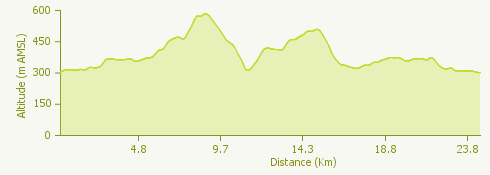
This round trip is for MTB, as more than 60% is on unsurfaced tracks and sometimes over rough terrain.
The route
Leave from the Town Hall of Omegna in the direction of Orta. After the ENI service station turn left to go up as far as the first turnoff to the right, in the village of Borca.
To the right of the little church of San Gottardo take the path which over more or less level terrain goes to Crabbia. There are some streams to ford along this path which are not always easy to cross. You should also look out for hikers on the trail.
When you get to Crabbia don’t go into the village but go up to the left on a road which starts out surfaced and then becomes a dirt track. You will come out at the cemetery of Agrano. From here continue to the right, passing some isolated houses, until you reach the fork for the hilltop of Barro.
Take the trail going down to the village of Pratolungo, and to the right of the little church of Madonna della Neve, where the Preia Grosa begins, continue down a rather steep descent, surfaced only in some places.
You will now come to the outskirts of the village of Pettenasco; turn left before the railway bridge. After the bridge over the Pescone stream take the track up to the right. In this way you come to a panoramic road leading to the village of Carcegna. Go through the village, keeping to the left. Continue on this trail until you get to the surfaced road going up to the left towards Armeno.
Before you get to the village, take a white trail to the left in open countryside, where after half a kilometre you can follow the signs for Pettenasco.
The descent here is quite steep and over rough terrain. When you get to the valley of the Pescone stream, go back under the railway bridge. At the fork there is a gentle slope up to the station and the village of Crabbia. When you get to the fork with the signposts go left to go back to Omegna, on the same trail as you came by.
Useful information
Buses run from Verbania to Omegna
Refreshment facilities: there are various bars and restaurants in Omegna and Pettenasco.