Starting point
The itinerary starts from the Old Church of Macugnaga near the Dorf (the ancient village with characteristic Walser houses).
How to get there
By car
A26 to Gravellona Toce, then continue on the same road, now a dual carriageway, in the direction of Domodossola-Sempione, exit at Piedimulera. From here a road goes up for 28 km along the Anzasca Valley.
By train
The nearest railway stations are Piedimulera and Domodossola. From here public and private transport is available for Macugnaga.
By bus
See the website VCO in bus.
General features of the route
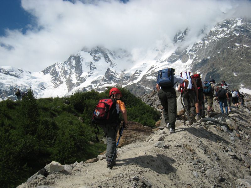
The route winds through a high mountain environment of traditional Walser houses and majestic, unspoiled natural surroundings. The outstanding feature is the imposing face of Monte Rosa – 3,000 metres of sheer rock and ice wall overlooking the dell where Macugnaga lies.
The route is entirely within the Wildlife Oasis of Macugnaga, and you should be able to see several species of wild animals.
The route
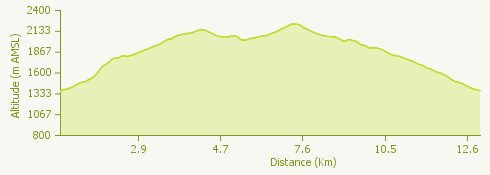
After going through the Dorf, the small Walser village, go up along an unsurfaced road to Burki, where you take a left turn to Alpe Rosareccio and the Piani Alti. This is the hardest part of the hike, with an ascent of 730 mt.
From the Piani Alti the route becomes panoramic, with views of the Monte Rosa peaks. The path leads to the dell of Pedriola where the Rifugio (Mountain hostel) Zamboni Zappa is located. Once you reach the hostel the path winds up through the boulders towards the vertical face of Monte Rosa, as far as Lake Locce.
The Zamboni Zappa hostel is a convenient point to stop for refreshment before you go down to the Pedriola alpeggio below and proceed towards the moraine ridge along the glacier.
After a pause at the Belvedere viewpoint to appreciate the full majesty of Monte Rosa, go on the chairlift station.
The path takes you along the side of the arrival point of the chairlift, then goes down with wide bends to the level area below, where the Rifugio Saronno is located. From here continue as far as the first chairlift station at Alpe Burki. This alpeggio is a popular place with visitors, as there are a restaurant and an agriturismo where you can sample traditional local produce.
This itinerary can be facilitated if you take the chairlift to Belvedere before walking the rest of the way to the Rifugio Zamboni and Lake Locce.
Useful information
See the website VCO in bus for the timetable of buses from Domodossola International Railway Station.
Refreshment facilities
Rifugio Zamboni Zappa, +39 0324 65313 - Rifugio Ghiacciai del Rosa, +39 340 0555702 - Ristorante Paradiso, +39 0324 65774 - Ristorante Wengwaldhutte, +39 347 1076691 - Agriturismo I Burki, +39 338 1657608 - Ristorante Seggiovia +39 0324 65071