Starting point
The itinerary starts from the covered car park outside Alpe Devero; you can get there by car or bus (Domodossola – Baceno and then the shuttle bus to Devero).
How to get there
By car
Autostrada A26 to Gravellona Toce; continue on the same road which is now called the SS “del Sempione”, passing Domodossola, as far as the exit for Crodo. Continue as far as Baceno (in the direction of Val Formazza); in Baceno turn left onto the road to Devero.
By train
The nearest station is Domodossola.
By bus
Bus to Baceno. Timetable from VCO in bus
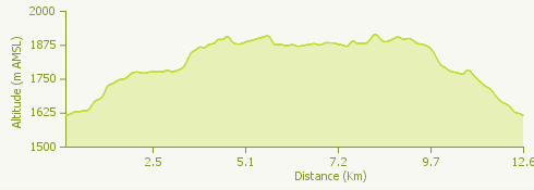
Short description of the route
Alpe Devero is in the north of Piedmont on the border with Switzerland; the nearest town is Baceno. It is one of the protected areas of Piedmont Region, and along with Alpe Veglia has formed the Veglia Devero Nature Park since 1990.
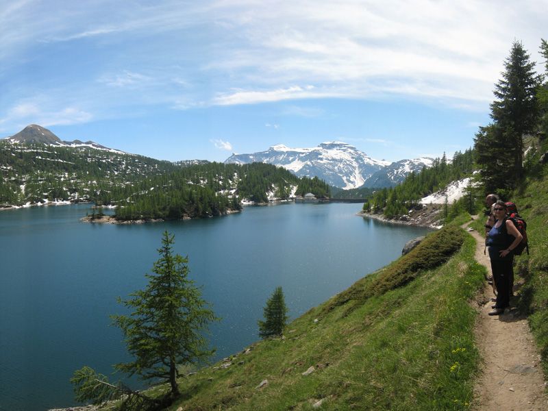
The park, very popular with visitors, is a ravishingly beautiful place. Larches, meadows bright with Alpine flowers, crystal clear lakes, jagged peaks and green mountain pastures make this a uniquely lovely mountain environment.
The route
From the car park a short stretch of paved path leads up to the first baite (mountain cottages) and the oratory church. After the church the path forks: one direction leads to the Piani di Buscagna and the other to the Devero plain.
Take the path to the Devero plain; cross the bridge and go past the turning to the right leading to Corte d’Ardui. After a fork in the path for Crampiolo, you will come to the hamlet of Canton, where there is a mountain hostel, the Rifugio Castiglione, and the Casa Vacanze La Rossa.
Here the path begins to go up, crossing a number of alpeggi (high mountain pastures) to reach the flat area of Crampiolo. A detour to the left takes you to the Laghetto delle Streghe (Witches’ Lake), famous for its exceptionally clear water.
Go back to the fork and continue towards a little bridge; at the end of the path is the dam. The path along the lake side goes to the alpeggio of Codelago, and continues through sparse larch woods, with superb views of Codelago, ending up at the fork for Pianboglio.
At the fork for Alpe Forno cross the bridge over the stream and take the path along the lake side. Go past the path for Alpe della Valle on your left, and you will come to the fork for the dam. From here on the path begins to go down to Crampiolo, a pretty mountain hamlet, with characteristic houses, guest houses and an agriturismo.
From Crampiolo take the track, passing on your right the path to the Lago delle Streghe, to reach the fork for Corte d’Ardui. At this point you can return to Devero along the picturesque Corte d’Ardui path or continue along the main track.
Useful information
Buses to Baceno leave from the international railway station of Domodossola. From Baceno there is a shuttle bus to Devero.
Refreshment facilities: see the website www.alpedevero.it